Bolivia
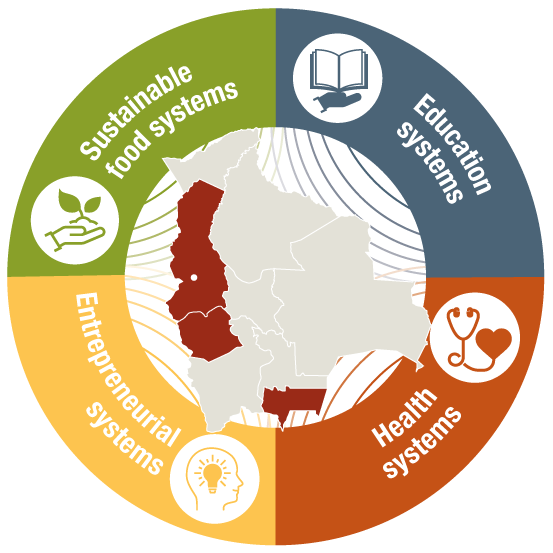
Departments of La Paz,
Oruro and Tarija
3
partners
1.704
people impacted in 2025
Louvain Coopération in Bolivia
Partners and donors
Partners
- Aprosar
- Alternativas
- Esperanza
- Bolivia
- IICC-UCB
- VLIR
Donors
- DGD
- IICC-UCB (TEAMS-VLIR) Resilient minds, sustainable futures
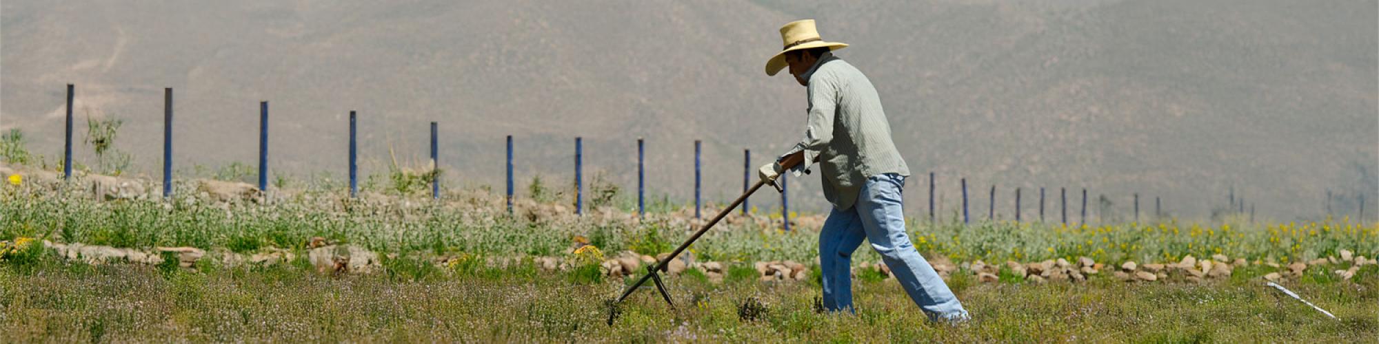
The context of Bolivia
Bolivia is a country rich in cultural diversity, with deep indigenous roots: its Constitution recognises 36 indigenous nations and numerous languages. Before the COVID-19 pandemic, it was often cited as one of the Latin American countries making the most progress towards the Sustainable Development Goals (SDGs).
However, this progress masks significant regional, ethnic and socio-economic inequalities, and the crisis caused by COVID-19 has amplified structural vulnerabilities, particularly for rural populations, women and children.
Health and nutrition
- Approximately 16.1% of children under the age of 5 suffer from chronic stunting, with even higher rates in rural areas. The causes include poverty and limited access to nutritious food and healthcare to prevent malnutrition.
- Anaemia affects a significant proportion of children and women of childbearing age, especially in rural areas and among indigenous populations.
- There is a double nutritional burden: persistent undernutrition and increasing overweight/obesity depending on living standards.
Gender-based violence and inequality
- In 2024/2025, more than 24,000 cases of gender-based violence (domestic, sexual, abuse) were reported nationally, according to judicial sources.
- Despite protective laws, violence remains widespread, often goes unpunished, and faces significant cultural, institutional and social barriers.
Socio-economic disparities and vulnerability
- One third of the working population depends on agriculture, often in conditions of low productivity, poor soil fertility or limited access to inputs.
- Poverty and precariousness result in difficulties in accessing essential services: health, education, infrastructure, especially in rural areas.
- There are many workers in the informal sector without a robust social safety net, which makes economic shocks particularly severe.
Impact of COVID-19 and the economic crisis
- The pandemic has exacerbated food insecurity, caused income losses for many, and disrupted access to education and healthcare.
- Already vulnerable populations—children, women, indigenous communities—have been the hardest hit by the multiple effects of the health, economic and social crisis.
- Regional impacts vary greatly: mountainous or remote areas, indigenous communities and disadvantaged rural areas are often the last to receive services or support.
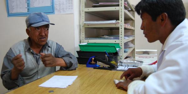
Living healthily and without violence
- Project duration:
Our objective:
To empower individuals and communities to demand and enforce their rights to health and a life free from violence for women and girls, by promoting dialogue, citizen participation and collective advocacy.
Our actions:
- Strengthening the quality of health services through continuing education for health personnel and the development of integrated care protocols for non-communicable diseases and gender-based violence.
- Adopting positive, family-centred, community-based and intercultural approaches to health, incorporating the promotion of positive masculinity and relationship models based on positive treatment.
- Promoting mutual aid and support among victims and patients through patient-centred services tailored to the needs of communities.
- Integrating health education into school curricula and raising awareness among the general public through health promoters.
- Training young leaders and community actors to promote health among their peers.
- Connecting people at risk in terms of mental health with the appropriate health services and actors.
- Advocating with authorities and on local and national platforms to improve access to and use of health services.
Our impact
This project contributes to improving the quality and accessibility of care, preventing chronic diseases, reducing gender-based violence and promoting an inclusive, participatory and human rights-based health culture.
Mental health resilience in the face of climate change in Bolivia
Our objective
To improve buen vivir — overall well-being — among rural and indigenous communities in Bolivia exposed to climate risks by strengthening their psychological and social resilience in the face of environmental crises. This project is led by UCB (Catholic University of Bolivia), with whom we are partners.
Our Actions
- Strengthening the research capacities of various partners on the links between climate change and mental health.
- Co-creating knowledge and local solutions with communities, authorities and development actors.
- Facilitating cross-sector collaboration to develop culturally relevant and sustainable prevention and adaptation programmes.
Our Impact
This project will strengthen people's resilience to the psychological effects of climate change, integrate mental health and community well-being into local policies, and consolidate the research and action capacities of UCB and its partners for a lasting impact.
Our concrete role
As a partner, Louvain Coopération is actively involved in all three components of the project, without being the main lead. Its key role is to mobilise Belgian cooperation actors and local partners around a ‘Mental Health and Climate Change’ network (HUB), to contribute its environmental and gender expertise, and to strengthen links with other rural and indigenous communities in order to amplify the project's impact.
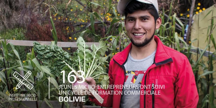
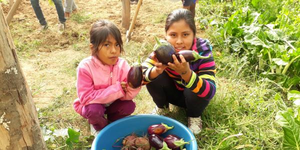
Promoting sustainable food systems
Our objective
To facilitate rural and peri-urban families' right to land, food and resources, while encouraging solidarity-based and sustainable entrepreneurial initiatives that serve communities and the environment.
Our actions:
- Technical and organisational support for producers, organisations, platforms and agricultural networks;
- Training and field assistance to support the agroecological transition of production systems;
- Raising awareness of a diversified diet in rural areas and in schools;
- Sustainable management of natural resources and strengthening resilience to climate change;
- OIE approach: monitoring of self-defined commitments to environmentally friendly agricultural practices;
- Support for economic initiatives (agricultural and non-agricultural) by strengthening production and marketing capacities;
- Promotion of short supply chains to bring producers and consumers closer together;
- Entrepreneurial training for women, aimed at economic autonomy, self-confidence and leadership;
- Integration of ICTs into production and marketing systems.
Our impact
This project contributes to improving food security, income and empowerment for rural families, while strengthening environmental sustainability and gender equality.
Our objective
To improve the economic fabric and employment in the Tarija region, in particular by improving the employability of young people and women.
Our actions
- Training and awareness-raising among public and private institutions to integrate the principles of circular economy and environmental sustainability into their management tools.
- Developing technical skills and employability among young people to improve their access to job opportunities or income-generating initiatives.
- Stimulating entrepreneurship and self-employment by supporting the creation of sustainable and profitable agricultural and non-agricultural micro-enterprises run by young people.
Our impact
This project promotes a more inclusive and sustainable local economy in the Tarija region, where young people are becoming key players in economic and social development. It strengthens women's participation, promotes gender equality and encourages environmentally friendly economic practices, thereby contributing to a better quality of life for rural and peri-urban communities.
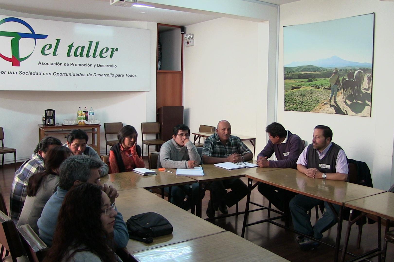
Our specific role
Louvain Coopération supports its partner, the NGO Esperanza Bolivia, which is leading the implementation of the project, by providing its expertise in social and solidarity economy, gender and environmental sustainability. In particular, we are helping to set up research on more specific issues and carry out analyses on different aspects of employment in Tarija.
Contact : info-aa@louvaincooperation.org
Find out more about our work in Bolivia
All videos from Bolivia +
FAQ
Roads remain the dominant means of connecting regions and borders, with routes that are sometimes winding in the mountains. Railways exist on certain routes, especially to neighbouring countries. Air links bring the Altiplano closer to the eastern plains. During the rainy season, some journeys are slower: it is important to plan ahead, monitor road conditions and choose stable travel windows.
- Road : main route, essential maintenance, caution at high altitudes.
- Rail: mainly regional and cross-border.
- Airplane : useful for quickly covering long distances and differences in altitude.
The country can be divided into ‘layers’. In the west, the Altiplano is a cold, dry Andean plateau with extreme temperature variations. In the centre, more temperate valleys alternate between farmland and towns. In the foothills, the Yungas offer humid and cloudy slopes, rich in microclimates. To the east lie the Amazonian plains, criss-crossed by rivers and forests, and further to the south-east, the drier Chaco.
- Altiplano: Andean crops (quinoa, potatoes), llama and alpaca farming.
- Valleys: market gardening, arboriculture, crossroads towns such as Cochabamba and Sucre.
- Yungas : mountain coffee, fruit, steep roads and microclimates.
- Amazon & Chaco: forests, fishing, livestock farming, with risks of flooding or drought depending on the area.
Bolivia has a population of over 11 million (2024 census). The population is now predominantly urban (around 7 out of 10 people live in cities), with major centres such as Santa Cruz de la Sierra, La Paz - El Alto and Cochabamba.
The demographic structure remains relatively young (median age around 26), although a gradual ageing process is beginning, which is most noticeable in the cities.
Health indicators show long-term progress but remain below the regional average: life expectancy is around 69 years (2023). Regional contrasts (altitude, access to services, rural/urban) remain significant, with sustained needs for water, transport and primary healthcare infrastructure to support urbanisation and city growth.
Economically, GDP per capita is expected to be around US$4,000 in 2024, placing the country in the lower-middle range for the region. The national poverty rate is estimated at around 36.5% in 2023; the trend remains sensitive to economic conditions, the performance of key sectors (agri-food, hydrocarbons, mining) and the weight of the informal economy in large urban areas.
Family farming produces quinoa, potatoes, corn, coffee and fruit, with some small-scale processing (cheese, flour, dried fruit). There are mineral and gas resources, as well as landscape-based tourism (Titicaca, Salar de Uyuni, Cordillera Real). Weekly markets and regional fairs structure trade.
In the long term, many areas are promoting more sustainable practices (soils, water, crop diversity), similar to agroecology and sustainable food systems, in order to secure incomes and access to healthy food.
The challenges vary depending on the environment: erosion and soil degradation at high altitudes, water management (storage, irrigation, protection of water catchment areas) in valleys, seasonal flooding and fires in certain plains, localised pressure on water resources in some areas, and the impact of climate change on water resources. catchment protection) in valleys, seasonal flooding and fires in certain plains, and localised pressure on forests in the Amazon and Chaco regions. The retreat of Andean glaciers is calling into question downstream uses, particularly for water and certain agricultural calendars.
The responses involve proven combinations: agroecological practices (cover crops, terraces/stone walls, organic matter), slope management (stabilisation, targeted reforestation), small-scale hydraulic works (reservoirs, canals, maintenance), adaptive fire management and monitoring of land use changes.
Between the Altiplano (La Paz ~3,600 m; El Alto ~4,000 m) and the valleys, the drop in atmospheric pressure reduces the partial pressure of oxygen (pO₂). The local populations are physiologically acclimatised, but the ‘thin air + strong sunlight’ environment requires lasting adaptations in transport, energy, public health and urban planning.
The tropical latitude (approximately 9° S to 22° S; La Paz ~16.5° S) places the sun very high in the zenith around the southern summer solstice, which increases radiation at altitude.
Key figures:
- Atmospheric pressure ≈ ~70 kPa at 3,000 m and ~62 kPa at 4,000 m (i.e. a pO₂ of approximately −30% to −40% vs sea level).
- Water boiling point ≈ ~90 °C at 3,000 m and ~86 °C at 4,000 m (direct impact on boiling and sterilisation).
- UV radiation: typical increase of approximately 10–12% per 1,000 m of altitude; sun close to the zenith at ~16–17° S in December–January.
Water & agri-food
Due to the lower boiling point, sterilisation and processing protocols (canned goods, milk/pasteurisation, commercial kitchen equipment) must be recalibrated (time/pressure) or carried out in an autoclave/controlled pressure environment; increased monitoring of hygiene and quality is required.
Public health
planning of oxygen therapy and pO₂-sensitive equipment (maternity wards, emergency rooms, operating theatres), organisation of medical transport and drug supply chains in high-altitude contexts.
Urban planning & facilities
Large day/night temperature variations, high UV levels and almost zenithal sunlight require shading, UV-resistant materials, façade protection and bioclimatic optimisation; in terms of energy, photovoltaics benefit from increased irradiation but require the choice of suitable materials.
These physical constraints, combined with the terrain, explain the specific engineering, health and organisational solutions in the Altiplano, particularly in the La Paz–El Alto area.
The climate varies greatly with altitude: the higher you go, the drier the air and the colder the nights. The valleys are milder, the Yungas are humid, and the eastern plains experience a marked rainy season. Agricultural calendars, mobility and even certain daily activities are adapted to these contrasts.
- Altiplano: dry air, significant difference between day and night temperatures.
- Valleys: temperate climate, diverse crops.
- East: seasonal rains, hot spells.
Castilian (Spanish) is the common language throughout the country, but Bolivia also recognises several indigenous languages, including Aymara and Quechua in the Andes and valleys, as well as Guaraní and other languages in the eastern lowlands. This diversity is reflected in local social and economic life, which is strongly rooted in ferias (weekly markets), regional festival calendars and craft production that varies according to the different ‘ecological zones’ (Altiplano, valleys, Yungas, Amazonia, Chaco).
Textiles (aguayos, alpaca or llama wool weavings), Andean music (charango, quena, zampoña) and dances such as the morenada, diablada, tinku and caporales are emblematic, particularly in the towns of the Altiplano. In terms of food, ecological diversity is reflected in the diet: quinoa and Andean tubers (including chuño), maize and legumes from the valleys, coffee from the Yungas, cocoa and tropical fruits from the lowlands. Internal mobility (city–countryside, valley–plateau) and bilingual schooling reinforce the circulation of languages and practices.
Llamas and alpacas are central to the pastoral economy of the Altiplano: they provide fibre (textiles, handicrafts), organic fertiliser for the fields and, in more localised areas, meat. Their adaptation to cold weather, steep slopes and low oxygen levels makes them key animals in areas where pastures are sparse and temperature variations are high. Vicuñas (a protected wild species) produce very fine fibre; there are regulated community shearing schemes in place, with traceability and conservation requirements.
- Value chains: fibre sorting, quality improvement, weavers' cooperatives, ethical/territorial labels.
- Pasture management: rotations, water points, basic health monitoring; prevention of overgrazing during dry periods.
- Complementarities: integration with Andean crops (quinoa, tubers), local value creation (weaving, clothing manufacture) and regional markets.
Bolivia is located in the heart of South America, between Brazil, Paraguay, Argentina, Chile and Peru. Its landlocked position means that most of its foreign trade passes through neighbouring countries, via access agreements, free trade zones and road and rail corridors. This landlocked position influences costs and lead times, and reinforces the importance of border towns and logistics platforms within the country.
In practice, this reality is compounded by Bolivia's contrasting geography: high plateaus, high mountain ranges, volcanoes, valleys and Amazonian forests, as well as varied climatic conditions, which complicate transport and travel.
La Paz (administrative capital) stretches across a valley at an altitude of around 3,600 metres, with an urban fabric clinging to the slopes and a network of cable cars facilitating connections.
El Alto, an adjacent municipality located on the edge of the Altiplano at an altitude of nearly 4,000 metres, is often described as the working-class suburb of La Paz: a large, young, commercial and dynamic city, but one that faces persistent challenges of rapid urbanisation, informality, unequal access to services and harsh climatic conditions.
Santa Cruz de la Sierra, located on the plains, is now the main economic hub, focused on agribusiness, trade and services.
Cochabamba acts as a crossroads between the valleys, while Sucre (the constitutional capital) and Potosí are reminders of the colonial and mining heritage.
Lake Titicaca, shared with Peru, the salt flats of Uyuni and Coipasa, the Cordillera Real mountain range, the spectacular roads of the Yungas and the Amazonian parks (Madidi, Noel Kempff Mercado) are among Bolivia's most spectacular landscapes. They illustrate the diversity of ecosystems, water uses and mountain and plain practices.
These sites also have a strong historical heritage: the ceremonial centre of Tiwanaku around Titicaca; the integration of part of the Altiplano into Collasuyu (southern province of the Inca Empire) and its Andean road network Qhapaq Ñan; then the colonial period marked by Potosí (Cerro Rico) and silver mining, which have permanently shaped the map of Bolivia.